Showing posts with label Ohio. Show all posts

Wednesday, 8 August 2018

Thousands left without power as storms move through Phoenix area


PHOENIX — If your phone was blowing up with warnings and alerts Wednesday night, you were not alone.
The National Weather Service issued both a dust storm warning and a flash flood warning for the Phoenix area.
The storms led to thousands of people getting their power knocked out, according to the APS and SRP outage maps.
The dust storm warning was in effect for parts of Maricopa and Pinal counties until 8:45 p.m.
The cities impacted included Phoenix, Mesa, Chandler, Glendale, Gilbert, Tempe, Avondale, Goodyear, Buckeye, Casa Grande, Paradise Valley and Laveen.
Mark O’Malley with the National Weather Service told KTAR News 92.3 FM said thunderstorms were creating strong winds, blowing dust and localized heavy rains.
Drivers were warned to expect visibility of less than a quarter mile with winds in excess of 40 mph. They were encouraged to avoid driving in the storms or pull over if they are caught in one.
“It’s not worth risking your life to drive through the dust,” O’Malley said.
An area of dust was seen extending from Laveen to Tempe to the Superstition Springs Mall at 20 mph around 7:40 p.m.
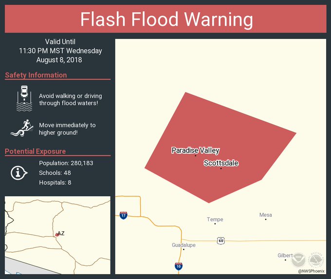
A flash flood warning was also issued for Maricopa County in south central Arizona until 11:30 p.m.
Storms were seen moving into the area around 7:20 p.m. and flash flood was expected to begin.
The areas affected included north Phoenix, north Scottsdale, Fountain Hills, Cave Creek and Carefree.
Drivers were encouraged to not be on the road during this time.
Pima Road in Scottsdale was also closed between Princess Drive and Legacy due to storm damage, Scottsdale police said.
KTAR News 92.3 FM’s Ashley Flood contributed to this report. 

Wednesday, 1 August 2018

Tornado Warning in Marion Ohio

A set of rogue tornado warnings issued Tuesday evening have expired.
The first two were issued in Champaign and Logan Counties from shortly before 9 p.m. until 9:30 p.m. Tuesday night.
A warning for Union County followed that was extended and expired at 10:30 p.m. The last came for Marion County, which expired at 11 p.m.
We have reports that funnel clouds were spotted, otherwise, both warnings were radar indicated for storms “capable of producing a tornado.”
So far we have no confirmation of touchdowns or any damage. This line of storms had almost no lightning or prior history of severe weather, which made this an odd situation.
The line should continue to weaken as we get further past sunset.
---
SEVERE WEATHER SAFETY GUIDE
DIFFERENCES BETWEEN WATCHES & WARNINGS
Watch
A Watch indicates the possibility of severe weather in a relatively broad area. For instance, a tornado watch means conditions are favorable for the development of tornadoes. Go about your normal routines, but watch for threatening weather.
Warning
A Warning is issued when severe weather is actually occurring. For instance, a tornado warning means a tornado has actually been sighted or has been indicated by radar. The warning usually encompasses a relatively small geographic area. If a warning is issued for the area in which you live, take cover immediately!
---
TORNADOES AREN'T THE ONLY REASON TO STAY ALERT
Strong Winds
Strong winds of 55 mph or more can cause significant damage even though no tornado is present. "Downbursts" are columns of air that slam to the earth and spread high winds in many directions. Downbursts can be just as damaging as tornadoes; if such conditions are present, take the same precautions as you would for a tornado.
Lightning
Lightning claims more lives every year than tornadoes. When lightning is a threat, stay indoors and don't use electrical appliances. If you're caught outside, keep a safe distance from tall objects, and try to stay lower than anything nearby. A safe distance from a tree is twice its height.
---
TAKING COVER
Storms producing tornadoes in Ohio often approach from the southwest. They can travel at speeds up to 70 miles per hour and contain winds estimated at over 200 miles per hour.

Sometimes an approaching tornado will sound like the roar of a train or airplane. If you see or hear a tornado, take cover immediately. Seek shelter inside, preferably below ground level. Do not waste time opening windows; tornado-force winds will "open" the windows well before the pressure difference can cause any structural damage. Above all, protect your head and lie flat.
At Home
Get away from windows, doors and outside walls. Go to the basement. If you have no basement, go to a first floor bathroom, closet or room at the center of the house. If possible, get under heavy furniture and cover your head with blankets or pillows.
At School
Go the lowest floor or basement. Go to small interior rooms or hallways. Stay away from windows and avoid auditoriums, gyms and other areas with wide, free-span roofs.
In Public Buildings
Go immediately to the designated shelter area or to an interior hallway or small room on the lowest level. Stay away from windows. Do not use elevators. Do not go to your car.

Contact Us

Name

Email *

Message *

Blog Archive